How to Have the Best Oregon Coast Road Trip
Trip dates: May 16, 2024 – May 21, 2024
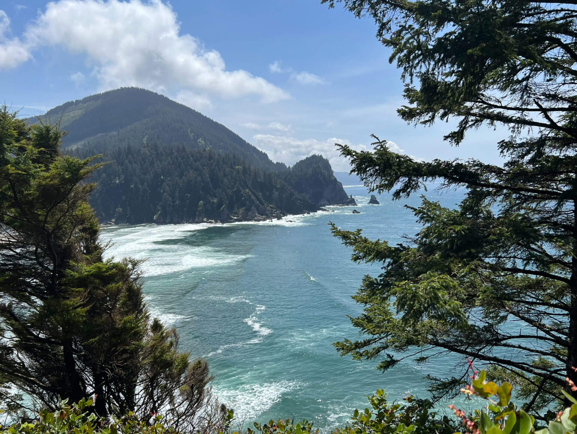
View from my favorite trail along the Oregon Coast, Cape Falcon – All photos in this post were taken on my iPhone 13 Pro
The Oregon Coast will always hold a special place in my heart because it was where I had my first solo road trip. Growing up next to the ocean, being near it again felt like returning home. This trip sparked my love for photography and ignited my passion for traveling whenever I can, even if it means going alone. There is something incredibly freeing and empowering about solo travel. You get to do things on your own terms, without compromising. In this post, I’ll cover each stop I made so you can gather some ideas for your own Oregon Coast road trip, whether you are traveling alone or with someone else!

How many days do you need
I spent about six days traveling along the Oregon Coast, including travel time to and from the area. I think this is an ideal amount of time to explore the main stops, but if you want to dive deeper into the coast, then a longer trip would be even better.
When to go
If you prefer smaller crowds, spring or fall is the best time to visit the coast. I traveled along the Oregon Coast in mid-May and got incredibly lucky with both the weather and the tides. It was sunny most of the time, and I happened to experience negative tides throughout my entire trip.
Summer is another great time to travel along the coast if you’re looking for long, sunny days. However, keep in mind that this is peak season, so you can expect larger crowds.
Where to stay
I recommend mapping out your stops and where you’ll be staying each night ahead of time, especially if you're visiting in the summer (lodging can fill up fast) or traveling alone. The coast has plenty of towns with hotels, as well as many campsites.

Itinerary
These are the stops that I made in order, from north to south, as well as where I slept each night:
Day 1
Traveled to northern Oregon
Sunset at Wreck of the Peter Iredale
Slept at The Seashore Inn on the Beach in Seaside
Day 2
Oswald West State Park (Ecola State Park north of Cannon Beach is another option, but they were closed when I went)
Slept at Netarts Surf Inn in Netarts
Day 3
Slept at Trollers Lodge in Depoe Bay
Day 4
Oregon Dunes National Recreation Area
Slept at this Airbnb near Coos Bay
Day 5
Oregon Islands National Wildlife Refuge
Face Rock State Scenic Viewpoint
Slept at SureStay Plus by Best Western in Gold Beach
Day 6
Samuel H. Boardman State Scenic Corridor
Traveled back home
Fort Stevens State Park
Fort Stevens State Park was originally a Civil War–era military fort established in 1863. The original earthen structure was built to prevent British and Confederate gunboats from entering the mouth of the Columbia River. In 1975, the site was officially designated as a state park. Two notable points of interest within the park are Battery Russell and the wreck of the Peter Iredale.
Battery Russel
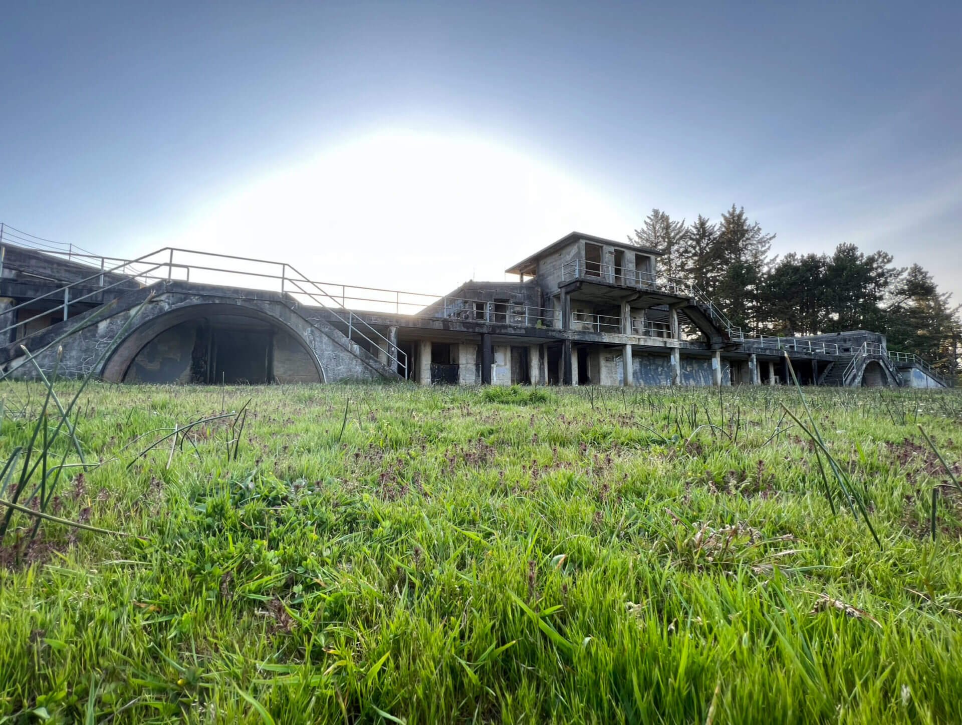
Battery Russel
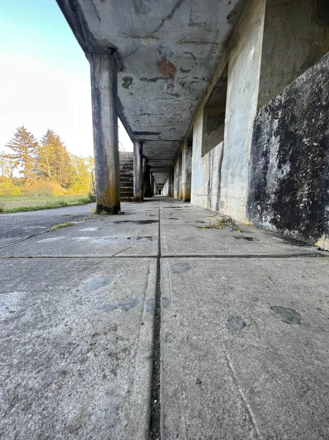
Battery Russell was completed in 1904 and remained in operation until the end of 1944. It was built south of the other batteries, facing the ocean, to expand the fort’s artillery coverage. Each of Battery Russell’s two 10-inch rifles was operated by a team of 35 men. A well-trained gun crew could fire a 617-pound shell up to eight miles away, at a rate of one round per minute.

Where the 10-inch rifles were kept
Walking around the battery, I couldn’t shake a slightly eerie feeling. After exploring, I looked up ghost stories associated with the site and found several accounts. Some described sightings of men in World War II–era military uniforms, strange orbs of light, and an overall unsettling atmosphere. You can read more about it here.

Wreck of the Peter Iredale

On September 26, 1906, the Peter Iredale departed from Mexico and sailed toward Portland to pick up a load of wheat bound for the United Kingdom. As it neared the mouth of the Columbia River, strong currents swept the ship off course, causing it to run aground at Clatsop Beach. The impact was so forceful that three of its masts snapped. Fortunately, none of the crew were injured, but the ship was abandoned and has remained there ever since. Over the years, waves, wind, and sand have slowly broken it down.


Cannon Beach
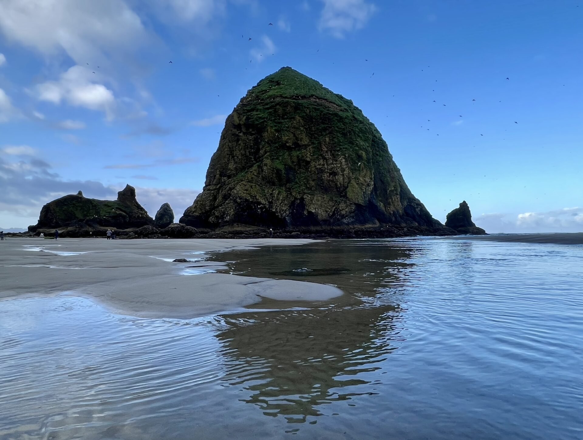
What’s a trip to the Oregon Coast without seeing the famous Haystack Rock, featured in The Goonies? Like many of us born in the '80s and '90s, The Goonies was one of my comfort movies growing up. The area around Haystack Rock on Cannon Beach is stunning, especially at low tide when tide pools appear (just be sure to follow the signs and avoid walking on them). I recommend visiting early in the morning to beat the crowds.
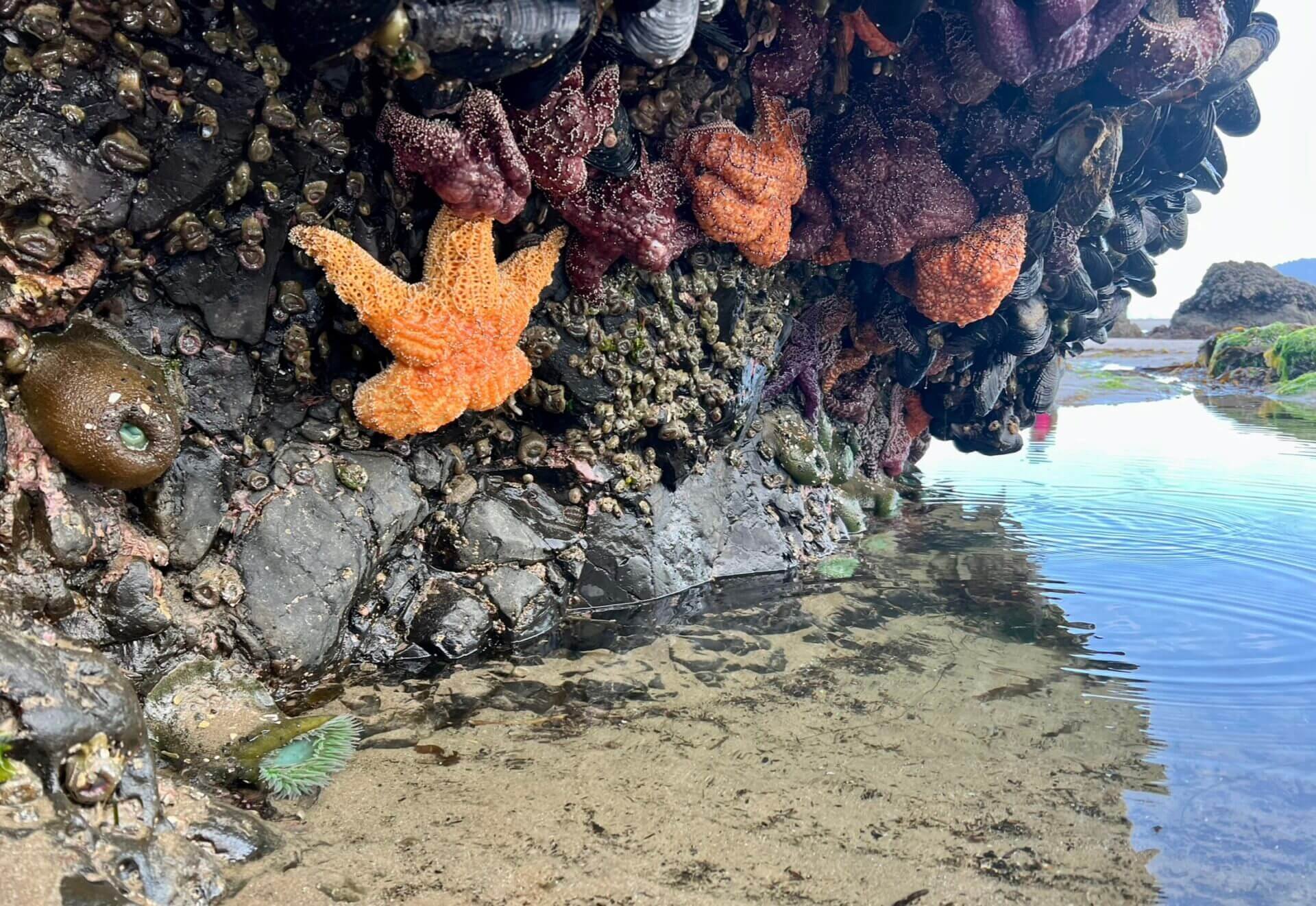
Tide pool with some thicc starfish
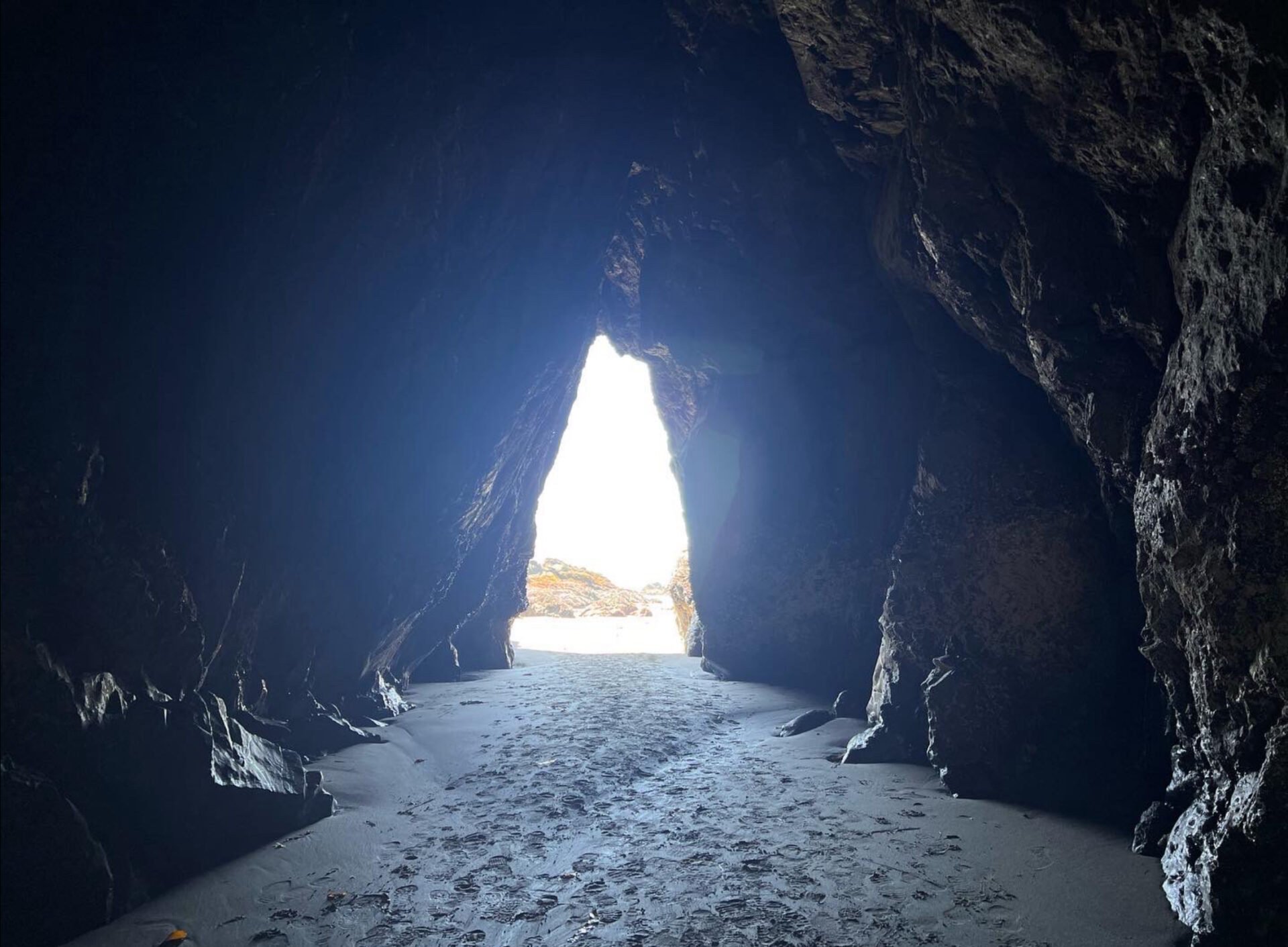
Hug Point

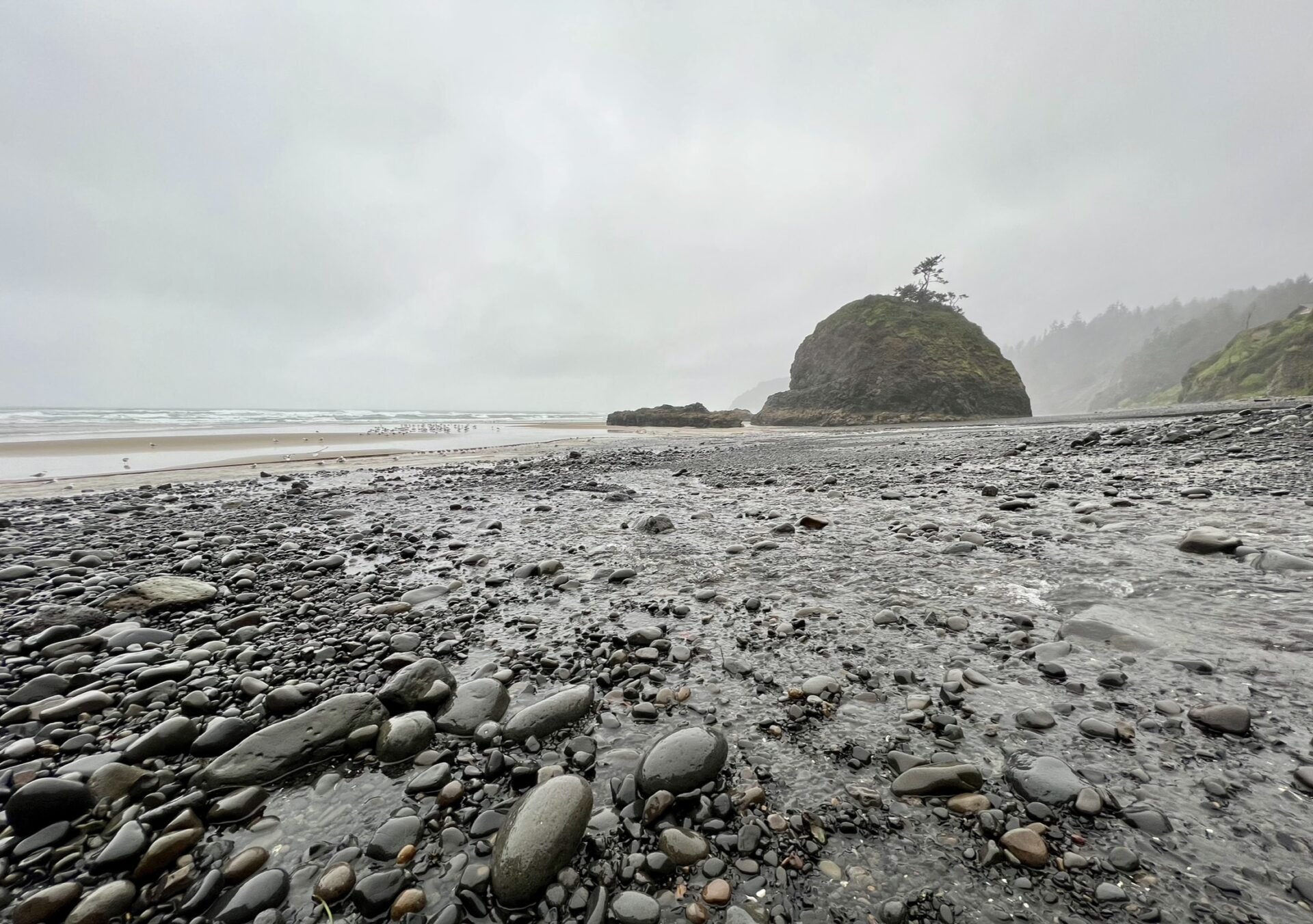
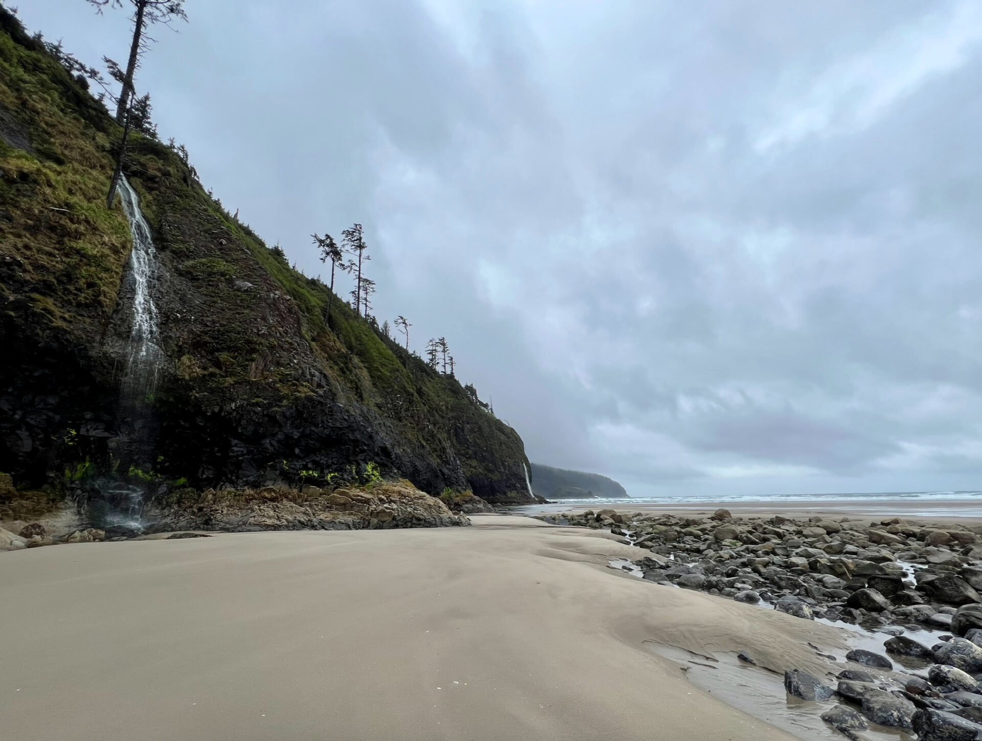
Hug Point is located just five miles south of Cannon Beach and offers a unique coastal experience. The beach features a small waterfall, a shallow cave, and several tide pools. You can easily spend a good amount of time here exploring, as the tide pools are full of sea life, often more so than at Cannon Beach. This is likely because Cannon Beach sees heavier foot traffic, which can disturb or damage fragile marine habitats.


Neahkahnie Viewpoint

This mountain summit offers one of the best views along the Oregon Coast, and the best part is that it’s located just off the highway! Neahkahnie is one of the highest points in Oregon at 1,661 feet, and its name translates to “home of the supreme being.”
Oswald West State Park
Since Ecola State Park was closed during my road trip, I searched for hikes in Oswald West State Park instead, and I’m so glad I did. Oswald is home to one of my all-time favorite hikes, Cape Falcon. This park ended up being the highlight of my trip, especially because I wasn’t planning to stop here and was pleasantly surprised.
Stretching across four miles of coastline and dense temperate rainforest, 2,484-acre Oswald West State Park offers a secluded sandy beach and miles of hiking trails, with breathtaking views of the Pacific Ocean. This scenic, lesser-known gem is without a doubt one of the most spectacular parks in Oregon. While there’s no shortage of hiking options in Oswald, I only explored the trails to Short Sand Beach and Cape Falcon.
Be sure to download a map ahead of time or bring a physical copy, as cell service in the park is very limited.
Short Sand Beach

Short Sand Beach is a popular surf spot, and you're likely to see surfers catching waves when you visit. You can access the beach either from the main parking lot or about half a mile into the trail to Cape Falcon. As you continue up the trail to Cape Falcon, you’ll catch glimpses of the beach through the trees, adding to the scenic hike.


Cape Falcon

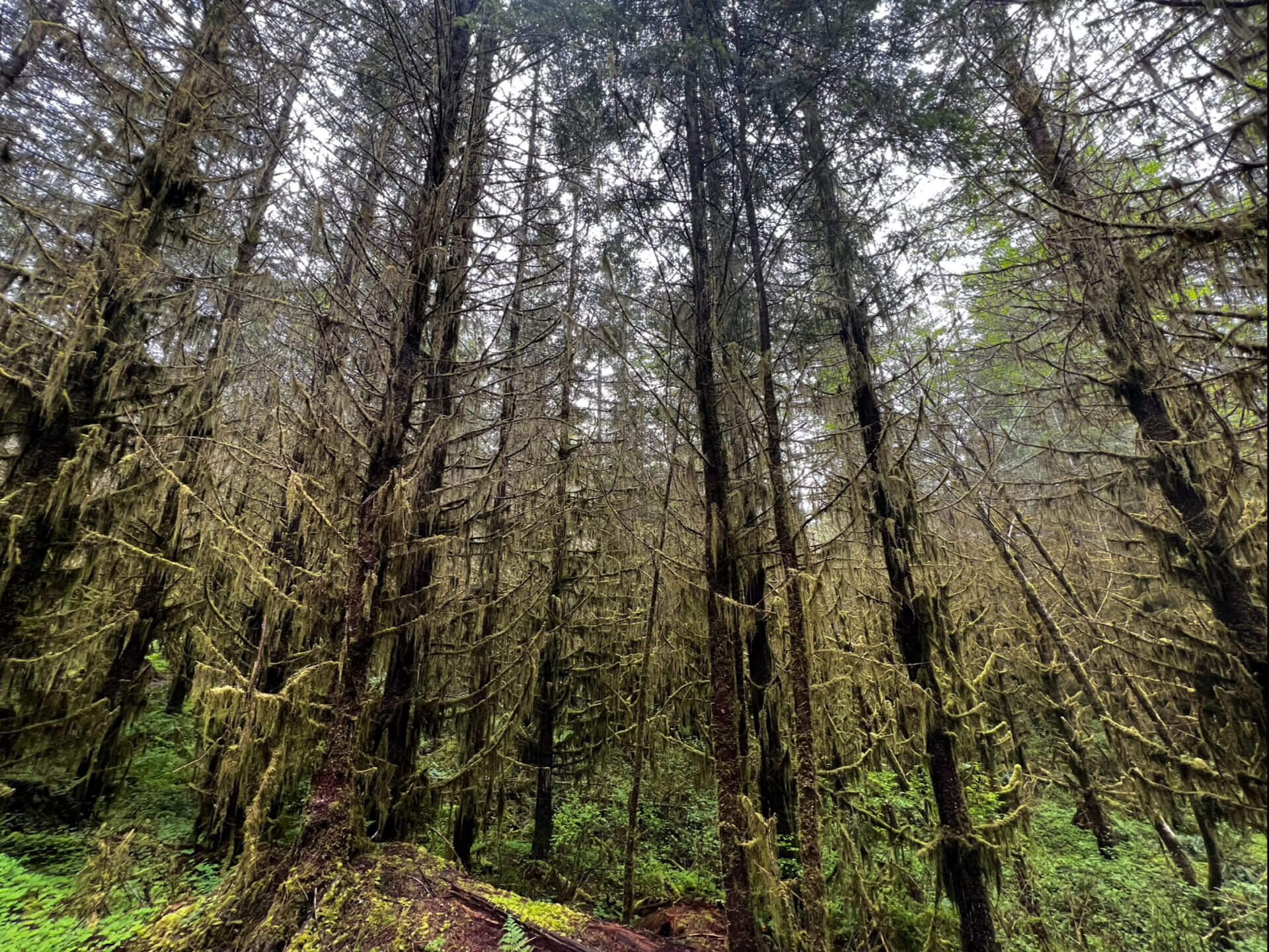
The hike to Cape Falcon is 5-miles round trip with a small 623 feet of elevation gain. Along the way, you'll be surrounded by an old-growth spruce forest, lush vegetation, small streams, and possibly even some wildlife. If you hike this trail in the spring, be prepared for mud, and lots of it. My boots were caked in mud like never before, and I eventually gave up trying to rinse them off in streams until the hike was over. I was shocked to see two women attempting the trail in light-colored Converse.

Found a banana slug crawling through the mud
When I reached the end of Cape Falcon, I had the entire viewpoint to myself. I sat near the edge, enjoyed a snack, and took in the stunning views in complete solitude. Just be cautious of where you step, it's a steep drop to the ocean below.

Muddy boots with a view
Tillamook Creamery
In my opinion, the Tillamook Creamery was a bit underwhelming. I was lucky it wasn’t crowded during my visit because I wouldn’t have wanted to wait in line to get inside. Judging by the massive parking lot, it’s clearly a popular tourist stop in the summer. If you catch it during a quieter time, it’s a fun place to take a short 30-minute break. And of course, you have to try some cheese or ice cream straight from the source.

Tillamook cookies and cream
Cape Meares

Cape Meares is part of the Three Capes Scenic Route, which also includes Cape Kiwanda and Cape Lookout. The Cape Meares Lighthouse is the shortest on the Oregon Coast and features a unique kerosene-powered lens. From the parking lot, a 0.5-mile paved loop takes you down to the lighthouse and back. Nearby, you’ll also find the Octopus Tree, a fascinating natural landmark. If you’re up for more adventure, there are several additional trails in the area to explore.


Short Beach
Short Beach is one of Oregon’s lesser-known coastal spots. This 1,000-meter stretch of shoreline features a small sea stack and waterfalls cascading from forested cliffs. Among the beach’s rocky surface, you might even spot agates and jasper. To reach the beach, park in the small lot up the hill at the marked trailhead. The short trail down includes a set of wooden steps and is much safer than it used to be, locals built the steps over 20 years ago after several people were injured attempting to descend the muddy hillside.
Cape Lookout State Park

The second stop along the Three Capes Scenic Route, Cape Lookout is located on a sand spit between Netarts Bay and the Pacific Ocean. There is a 4.7-mile trail that leads out to Cape Lookout, but I wasn’t able to hike it due to downed trees and a broken bridge. If the trail is still closed when you visit, you can opt to take a stroll along the beach instead like I did. To the left, you’ll find a series of cliffside waterfalls cascading onto the sand and flowing into the ocean, a beautiful alternative to the hike.


Cape Kiwanda

Our third and final stop along the Three Capes Scenic Route brings us to Cape Kiwanda. To access the cape, park in the center of Pacific City near the beach. Cape Kiwanda is just a short walk from the parking lot. Be sure to wear footwear that you don't mind getting sandy because you’ll need to scale the sand dune to get to the top of the cape. Once you reach the top, you will be rewarded with gorgeous views.


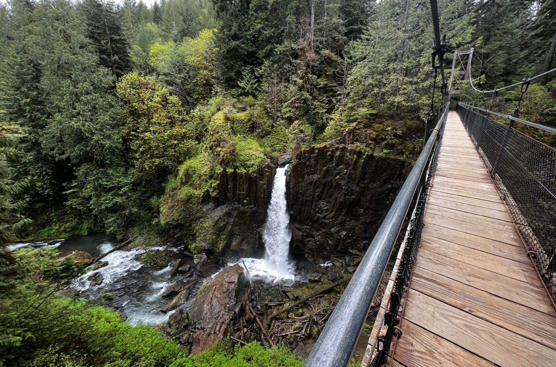
Drift Creek Falls

Drift Creek Falls is tucked away in a remote area, accessible via a forest service road. Be sure to map out your route ahead of time, as there is no cell service on this road. The hike to the falls is 3.1-miles and relatively easy with an elevation gain of 525 feet. Throughout most of the hike, you'll be surrounded by a lush coastal forest filled with greenery and moss.
70-year-old regrowth of Douglas-fir, western hemlock, and a few Sitka spruce
You’ll know you’re near the end of the trail when you reach the 240-foot suspension bridge, which hangs 100 feet above the canyon floor. If you’re afraid of heights like I am, crossing this bridge can be a heart-pounding experience. However, the bridge is very secure, and the breathtaking views of the canyon almost make you forget just how high up you are.


Devil’s Punchbowl Arch
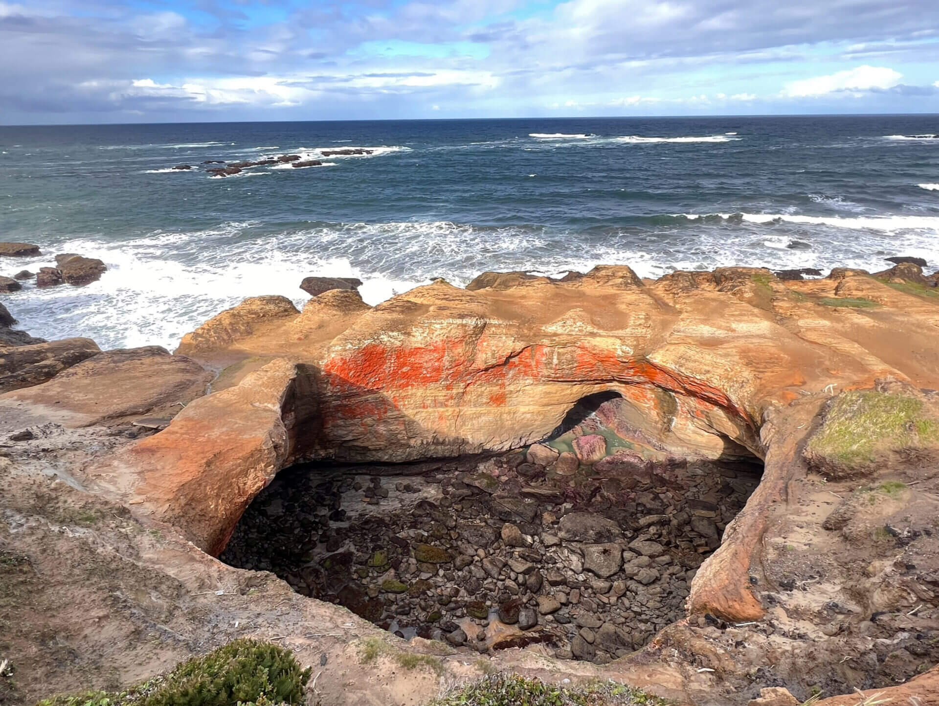
Devil’s Punchbowl is one of the most unique geological formations I’ve ever seen. It's believed that the bowl was formed ages ago by the collapse of two sea caves. Waves now rush into the hollow space, swirling, foaming, and continuing to shape it over time. I arrived early in the morning at low tide, and as you can see in the photo above, the bowl was empty of seawater.
I had seen photos taken from inside the bowl and was determined to explore it while the tide was low. Never attempt this at high tide or when the tide is coming in, it’s extremely dangerous. If you park near Otter Crest Beach, just a short drive north of the bowl, you can access the interior by walking south along the beach. Be prepared to climb over some rocks, which may still be slippery from ocean spray, so take your time and watch your footing.


Yaquina Head Lighthouse
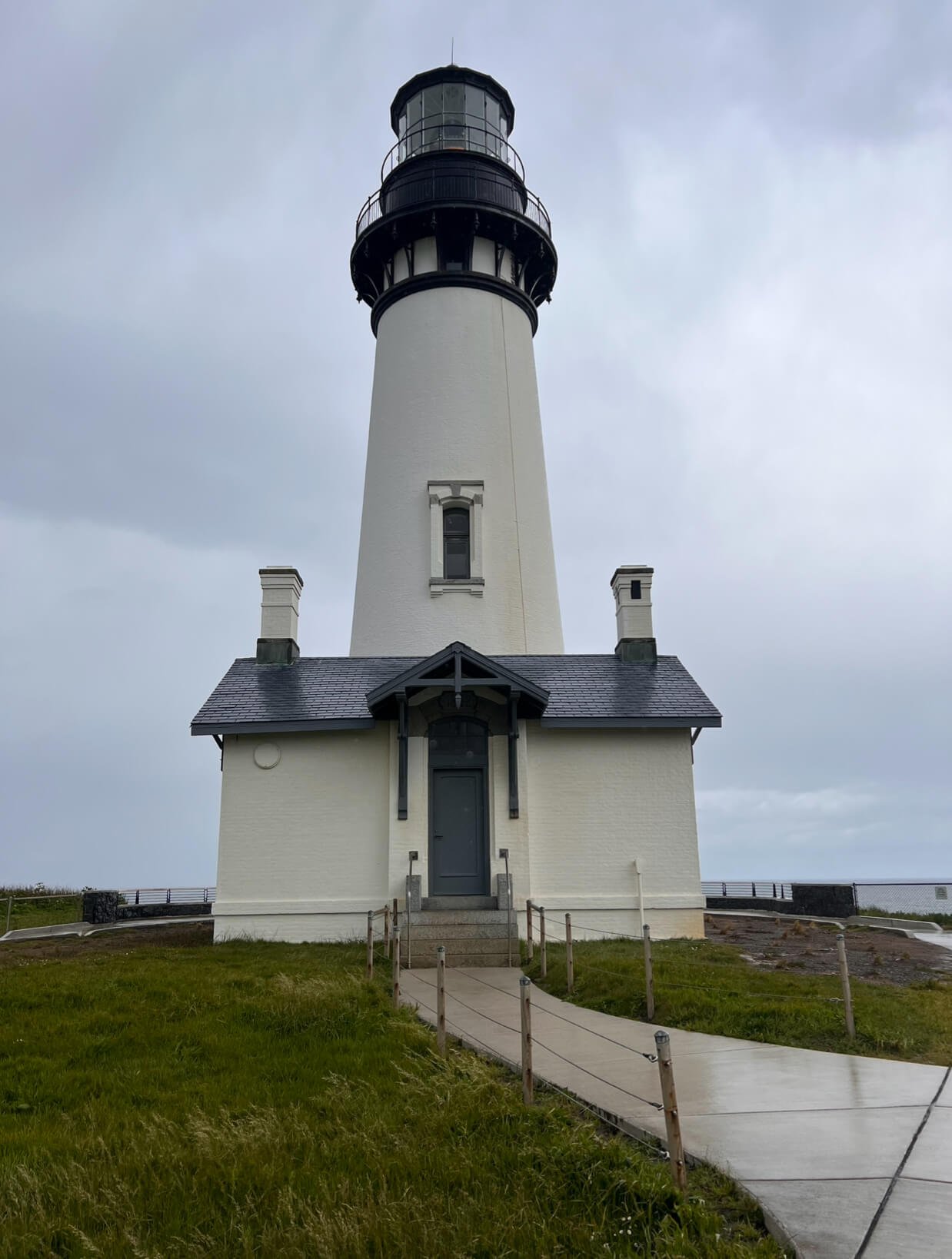
Built in 1871 and decommissioned just three years later, Yaquina Bay Lighthouse sits at the mouth of the Yaquina River. It was fairly crowded during my visit, likely because it’s one of the most easily accessible lighthouses along the highway. A small fee is required for entry, and parking is limited. Just a few steps down the bluff, you’ll find the scenic Cobble Beach.

Cape Perpetua Scenic Area

View from Cape Perpetua Lookout
Cape Perpetua is home to several iconic spots along the Oregon Coast, including Cape Perpetua Lookout and Thor’s Well. It’s one of the most beautiful places on the coast and was one of my favorite stops. The visitor center serves as the starting point for many hikes, and you can purchase a $5 day pass for the area. I highly recommend camping at the local campground, as it’s easy to spend an entire day exploring and taking in the views. But if you're short on time, I’ll highlight a few must-see spots.
Cape Perpetua Lookout
The Cape Perpetua Lookout is the highest viewpoint accessible by car along the Oregon Coast. A short 0.2-mile loop trail circles the lookout, offering panoramic views of the coastline. If you're up for a workout, there's also a steep 2.8-mile round trip hike from the visitor center up to the lookout.
Giant Spruce
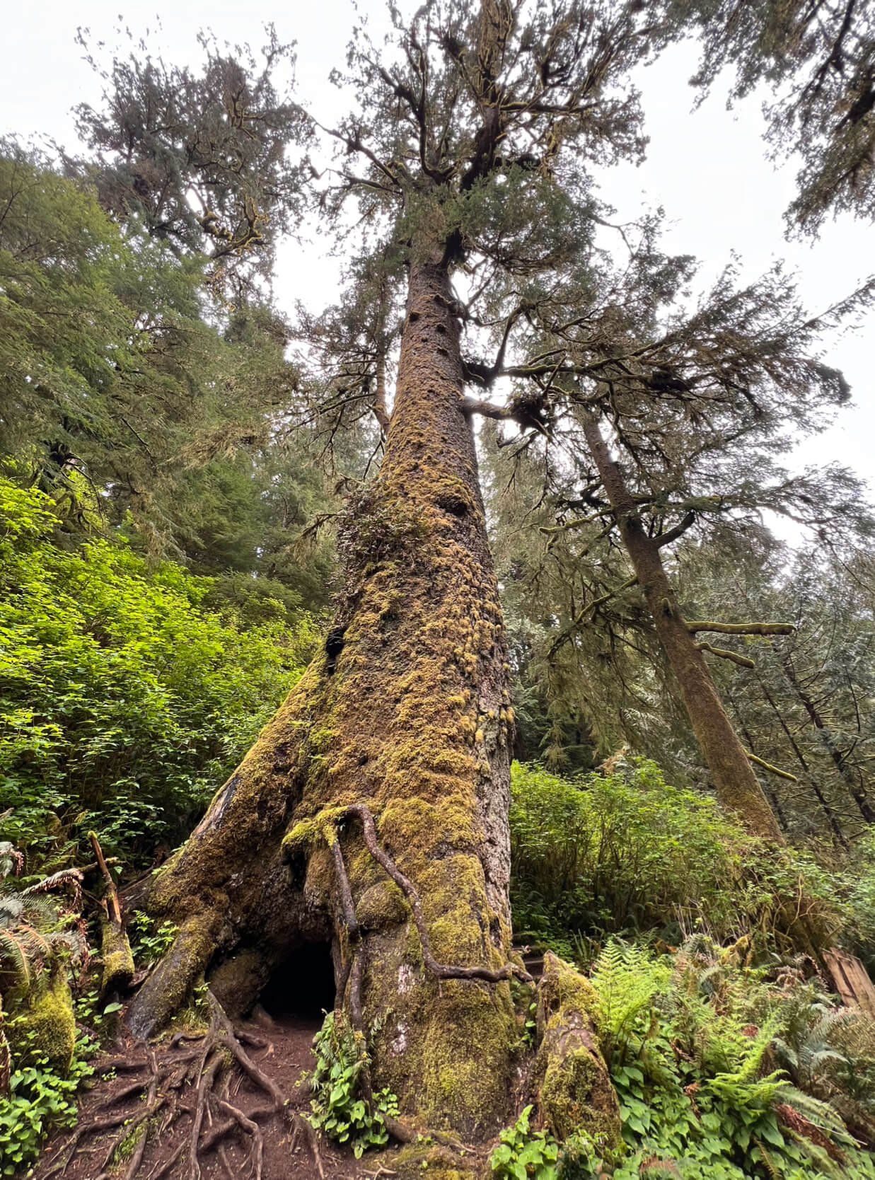
The hike to the Giant Spruce is an easy, flat 2-mile round trip. This impressive tree is over 450 years old, stands 185 feet tall, and has a circumference of 40 feet.
Devil’s Churn
To visit the next few spots, I recommend parking at Devil’s Churn. From there, you can take an easy 1.4-mile round trip walk that leads all the way to Spouting Horn. This route lets you see Devil’s Churn, Thor’s Well, Cook’s Chasm, and Spouting Horn without needing to move your car multiple times. For the most dramatic experience, try to visit these coastal landmarks during high tide or as the tide is coming in. This is when the waves are most powerful, and you’ll see seawater shoot into the air.

Devil’s Churn was formed over thousands of years as relentless wave action carved into the basalt shoreline. During high tide or winter storms, the crashing waves and churning water inside the narrow inlet create a dramatic display. Ocean spray can reach up to 200 feet into the air as the waves surge in and out of the chasm.
Thor’s Well

Once shrouded in mystery, Thor’s Well is a bowl-shaped hole carved into the basalt shoreline of Cape Perpetua. Known as the "Drainpipe of the Pacific," the well appears bottomless as it fills and drains throughout the day. Despite its dramatic appearance, the well is only about 20 feet deep. During high tide, water erupts from the top like a geyser, reaching heights of up to 40 feet.
Originally thought to be a giant sinkhole, researchers now believe that Thor’s Well began as a large sea cave. Over thousands of years, waves relentlessly battered the volcanic rock of Cape Perpetua’s shoreline, slowly carving out the cave until it eventually collapsed, leaving the bowl-shaped hole we see today.
Cook’s Chasm & Spouting Horn
Of all the spots at Cape Perpetua, my absolute favorite was Spouting Horn at Cook’s Chasm. It was the first time I had ever seen an ocean geyser in action. As incoming waves funneled seawater and air into the cave below, pressure would build and erupt into a misty fountain. The sound was eerily similar to a whale surfacing for air, deep and powerful. I was completely mesmerized, spending nearly an hour watching waves explode through the geyser.


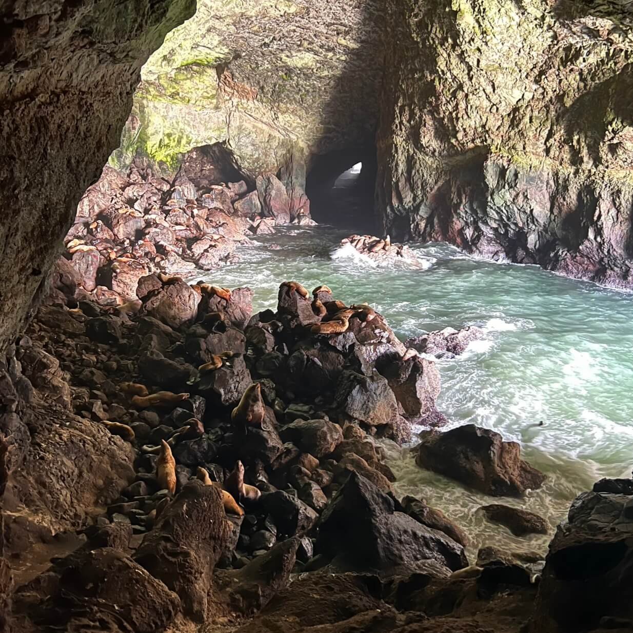
Sea Lion Caves
The Sea Lion Caves is a network of sea caves and caverns that open to the Pacific Ocean, and it’s the largest sea cave in America. Sea lions inhabit the caves during the spring and winter months, while in the summer, they can be found lounging on the rocky ledges just outside. A $14 fee grants access to a 208-foot elevator ride down to the caves, where you can view the sea lions. While the viewing area isn’t very large, there’s plenty to explore on this self-guided tour.

Oregon Dunes National Recreation Area
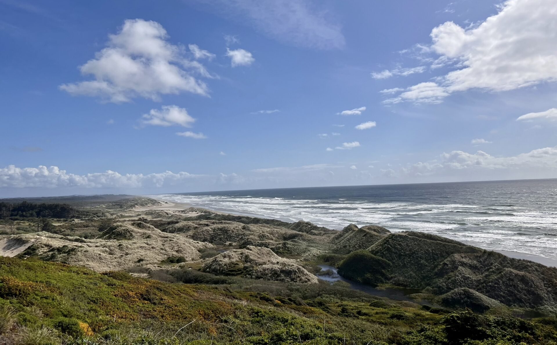
The Oregon Dunes National Recreation Area, located at the southern end of the Siuslaw National Forest, is home to one of the largest expanses of temperate coastal sand dunes in the world. This 40-mile recreational area features thirty lakes, dunes, campgrounds, and hiking trails. Two of the most popular activities in the dunes are sand surfing and off-road vehicle adventures.
Cape Arago Highway
The Cape Arago Scenic Highway is a 14-mile route that connects three stunning state parks. Explore tide pools in the sheltered cove of Sunset Bay, take in the dramatic sandstone cliffs at Shore Acres, or watch sea lions barking along the rocky shores of Cape Arago. If you're up for hiking, the parks are linked by the Oregon Coast Trail, with plenty of additional trails to explore. Keep an eye out for scenic viewpoints along the highway, you’ll find plenty of opportunities to stop and soak in the views.
Sunset Bay State Park
Sunset Beach
Sunset Bay State Park is the nearest of the three state parks to the Cape Arago Lighthouse. Although the lighthouse sits on a small island and isn’t open to the public, it’s still a scenic landmark worth viewing from afar. According to local legend, the park’s sheltered cove may have once served as a hideout for pirate ships.


Shore Acres State Park

Shore Acres State Park was once the grand estate of lumber baron Louis J. Simpson, who built a summer home here as a gift to his wife. Today, an enclosed observatory stands where the mansion once overlooked the coast. The park’s formal garden, a lasting legacy of the Simpson estate, has been lovingly maintained by skilled gardeners over the years. From spring through fall, the garden bursts with colorful blooms, it's also where I saw my first ever hummingbird. In addition to the short stroll through the gardens, a 1.2-mile loop trail leads from the parking lot along the coastline and through the surrounding forest.


Cape Arago State Park

The Cape Arago Highway ends at Cape Arago State Park, one of the best spots on the Oregon Coast for wildlife viewing, especially seals and sea lions. As I explored the cliffs, I could hear sea lions barking from a nearby island in Middle Cove.
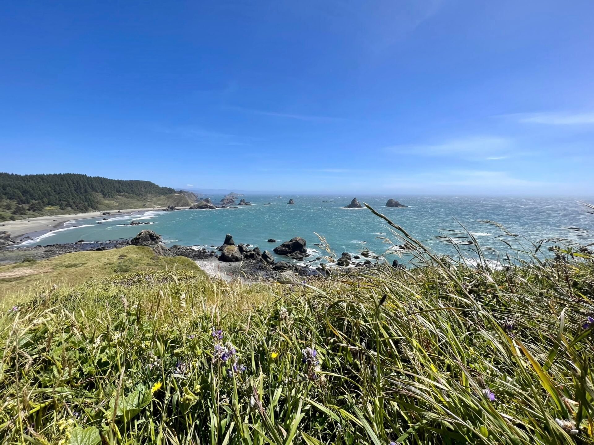
Oregon Islands National Wildlife Refuge

The Oregon Islands National Wildlife Refuge spans 320 miles of the Oregon Coast and includes 1,853 rocks, reefs, islands, and two headland areas. One of its mainland units, Coquille Point, is an incredible spot to observe wildlife and explore the shoreline. From the point, you can view a cluster of offshore rocks, each uniquely shaped, providing habitat for thousands of seabirds and harbor seals. A paved trail winds across the headland, featuring interpretive panels that highlight local wildlife and Native American history. Stairways on either side of the point lead down to the beach, allowing visitors to complete a scenic loop along the shore.
Face Rock State Scenic Viewpoint

Just two minutes south of the Oregon Islands National Wildlife Refuge is Face Rock Viewpoint, a spot steeped in Native American legend. According to the tale, some visitors claim to hear a maiden’s voice carried on the wind. From the cliffside overlook, it’s easy to spot the distinct profile of a face in the offshore rock formation known as Face Rock. A well-maintained trail leads down to the beach, where you can explore a variety of rocky intertidal areas during low tide.
Samuel H. Boardman State Scenic Corridor
The Samuel H. Boardman State Scenic Corridor stretches for 12 miles along a steep, rugged coastline blanketed in dense forest, with a few small sandy beaches tucked between the cliffs. This area is filled with hidden gems, and you could easily spend several days exploring its many viewpoints and trails. I only had time to stop at a few spots, but each one was absolutely breathtaking.
Arch Rock State Park

A short path from the parking lot leads to an overlook with stunning views of offshore sea stacks and islands. The Arch Rock stop is quick and easy, but offers a truly beautiful vantage point.
Secret Beach

Secret Beach, while no longer a true hidden gem, remains relatively obscure due to its unmarked access point and steep descent. Located approximately one-third of a mile south of milepost 34 on Highway 101, the beach is accessed via a small gravel turnout. The trail to the shoreline is brief but steep, requiring careful footing. It is important to note that much of the beach is only accessible at low tide. Upon arrival, the beach reveals a dynamic coastal environment featuring a freshwater stream flowing directly into the Pacific, as well as numerous geological features including sea stacks, coastal tunnels, and tide pools.


Thunder Rock Cove
Finding the small parking lot for Thunder Cove can be tricky. It is located between Secret Beach and the Natural Bridges. The hike out to the cove is a short 0.8 miles. If you walk just a little further past the cove you will have views of Seal Cove to the left and Secret Beach to the right.


When a large wave enters Thunder Cove, it wraps around into a sea cave on the cliff. The wave forces water and air into the back of the cave, building pressure. As the wave reaches the back, the air and water can’t move any further, resulting in a thunderous sound as the wave and air are thrust backward. On calm days, this sound can still be heard with the occasional wave, but it’s much more pronounced during large swells and storms. You might assume this thunderous noise is how Thunder Cove got its name, but in fact, it was named by explorers Peter Warren Dease and Thomas Simpson after a thunderstorm passed through the area.
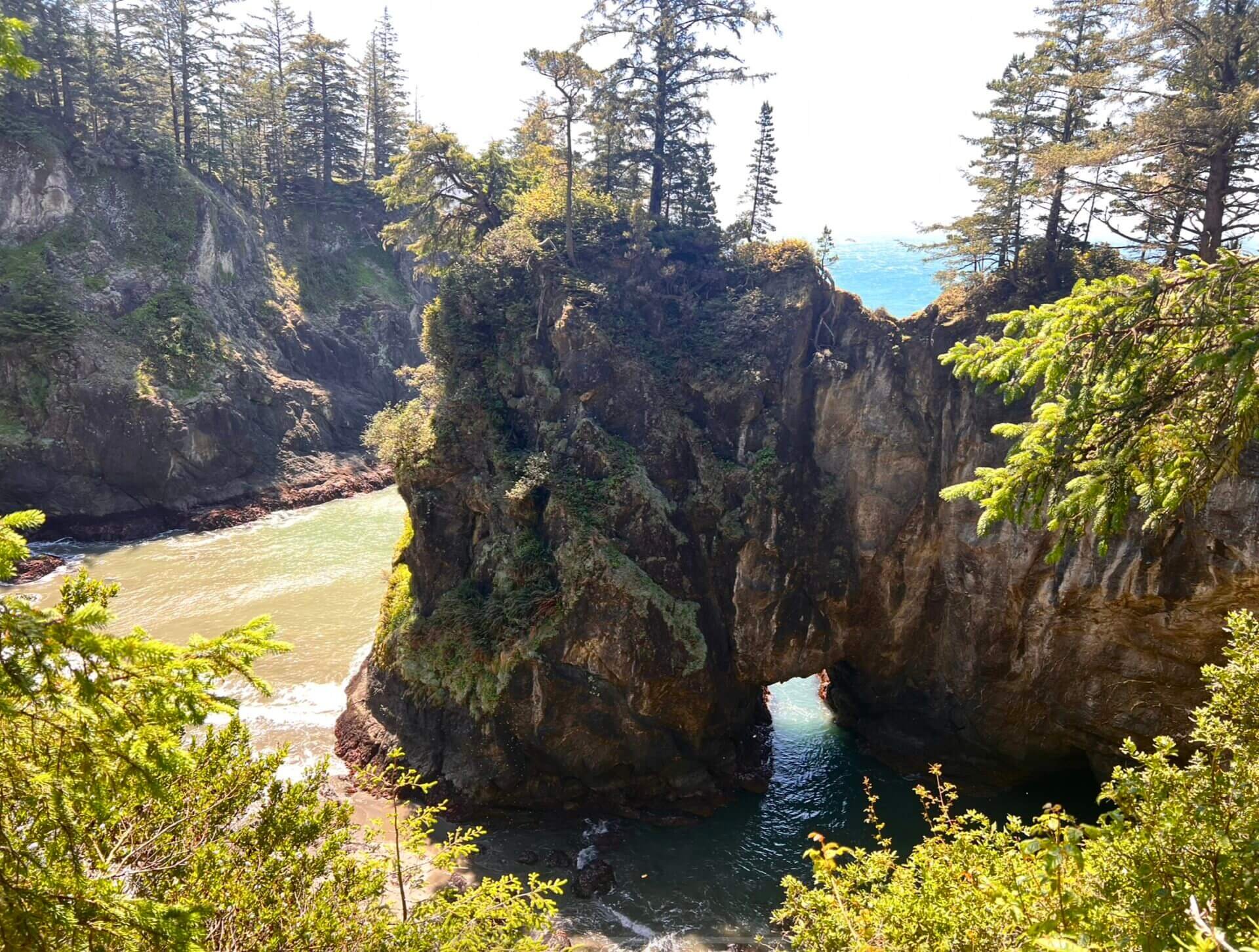
Natural Bridges
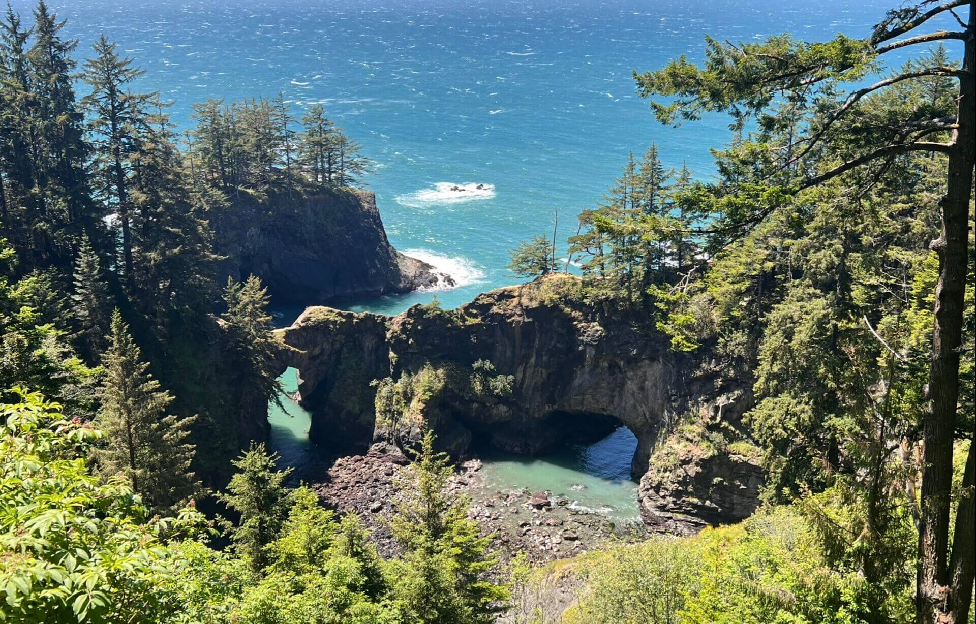
Natural Bridges is arguably the most popular stop along the corridor. Just a short walk from the parking lot, a large wooden platform provides a stunning view of the bridges below. There are two trails that lead down to the bridges, allowing you to walk across them, but this is extremely dangerous and only recommended for experienced hikers with proper gear. If the rocks are wet or slippery from rain, it’s best to avoid crossing altogether.
Tragically, there have been a few fatalities from people attempting to cross, so use extreme caution. When I visited, I saw an EMT truck nearby, likely responding to someone injured on the trail rather than on the bridges themselves (or at least I hope so). I personally chose not to attempt the trail, as crossing the bridges alone didn’t feel worth the risk.
Cape Ferrelo Viewpoint


Cape Ferrelo Viewpoint is a short, one-mile hike that leads to a grassy, windswept cape with sweeping views of the Oregon coast. It was certainly living up to its reputation the day I visited, I was battling strong gusts the entire way. Despite the wind, this ended up being one of my favorite stops along the corridor, especially because I had the entire cape to myself.

Note for the reader: I share these locations so that others can see beautiful places and enjoy nature as much as I do. Please be respectful of the outdoors and what condition it is in when you visit. Don’t go off trail, leave no trace, and pack out what you came in with.